01 May 2001

A New Understanding of the Groundwater Resources of the Great Artesian Basin

Groundwater is an essential source of water supply and a critical base for food supply in many parts of the world. Groundwater is especially important in some of the drier and poorer countries, for example, the Middle East and North Africa. In almost all cases the groundwater supply is declining. In some cases, serious international disputes are arising about access to remaining supplies.

Lance Endersbee Professor Lance Endersbee
This Occasional Paper by Emeritus Professor Lance A Endersbee AO FTSE provides a background on our understanding of the groundwater of the Great Artesian Basin.

Preamble

Groundwater is an essential source of water supply and a critical base for food supply in many parts of the world. Groundwater is especially important in some of the drier and poorer countries, for example, the Middle East and North Africa. In almost all cases the groundwater supply is declining. In some cases, serious international disputes are arising about access to remaining supplies.

At the core of the problem is the mistaken belief that the source of all groundwater is rainfall on exposed sediments, creating an illusion of perennial recharge. The illusion is based on the idea that the groundwater accumulates by seepage along aquifers that are exposed somewhere to surface rainfall.

Even though such flow of groundwater ( over very long distances and with little or no head loss), can be shown to be physically impossible, the fallacy continues despite disturbing evidence of declining flows.

The mistaken belief continues because the authorities involved, and indeed the professions, cannot comprehend any alternative source of supply of groundwater other than surface rainfall.

The Great Artesian Basin of Australia is the largest artesian basin in the world. Total flows from bores have been declining for almost a century, despite an increasing number of bores. There is a similar misconception about recharge from surface rainfall.

In the paper the author demonstrates that the groundwater in the Great Artesian Basin is derived from deep within the Earth. It was part of the original composition of the Earth. These groundwaters have the same source as the steam that explodes from volcanoes, and the hot acid waters that gush from the deep ocean vents.

The paper refers to the exciting progress that is being made in our understanding of the universe and the Earth. The new knowledge enables a new understanding of the sources of groundwater around the world. The paper focuses on the origin of groundwater and natural gas in the Great Artesian Basin, and the implications for resource management.


Hydrogen

There is increasing evidence that hydrogen, and basic hydrogen compounds (such as water, methane, ammonia and hydrogen sulphide) are abundant in space. Hydrogen comprises about 70 to 75 percent of the visible matter in the universe. This suggests that hydrogen and hydrogen compounds may have constituted a large part of the original accumulation of space debris that coalesced by gravitational attraction to form the Earth, and may still constitute a large part of the Earth.

Today we have the benefit of space observatories with advanced telescopes. But there were scientists a century ago who were reaching the same conclusions by their own studies of the behaviour of the crust of the Earth, and their speculations about the origin of the deposits of metal minerals.

Water as steam obviously has a role as a ballistic propellant in volcanoes. Metal minerals are evidently deposited as precipitates from strong hydrothermal solutions. But, for the past century, most scientists have had difficulty with the view that there may be water (or worse, methane) deep within the Earth. Convoluted arguments were developed to show that all water originated as surface rainfall, and that all natural gas and petroleum are entirely due to biological sources similar to the way coal is sourced from vegetable matter .

One of the early scientists who had a broad understanding of the possible evolution of the Earth was J. W. Gregory, D.Sc., FRS, who for a short period from 1900 to 1904 was Professor of Geology at the University of Melbourne. When Gregory inspected the flowing wells of the Artesian Basin in 1901-2, and later studied the records of flows, temperatures and chemical composition of the waters, he concluded that the waters had never been surface waters and were part of the original constitution of the Earth.

He noted that there was an adjacent north-south zone of volcanism and basalt fields extending from Torres Strait to Tasmania, and deduced that the volcanic waters and the water from the flowing wells probably derived from the same deep sources. There were metal mineral mines all around the perimeter of the Artesian Basin. Those metal deposits must have been the result of precipitation from hot, concentrated geothermal solutions. Gregory believed that the hydrothermal solutions probably derived from the same deep sources of water as the volcanism and the flowing wells.

At that time in the first decade of the century Gregory was the sole advocate of the concept that the waters in the Great Artesian Basin came from the Earth itself, and were not derived from rainwater. Gregory's analysis was thoroughly rejected at the time, and has been thoroughly rejected for the past 100 years. But I believe he was quite right, and outstandingly perceptive.

Historical introduction to the Great Artesian Basin

Drilling of water bores into the Great Artesian Basin began in 1882. The first deep bores to or near bedrock discharged great fountains of water into the air. The flowing wells were allowed to run continuously, and after a time the flows of water began to decline. Even before the end of the 1880's there was concern about the waste of water.

Legislation to prevent the continued enormous waste of water was passed by the Lower House of Parliament in Queensland in 1891. But the Upper House rejected the Bill, believing that the outflow from the wells was insignificant compared with the abundant continued recharge of the wells from rainfall. The proposed legislation was dropped as unnecessary. That fallacious belief has continued for the past 110 years.

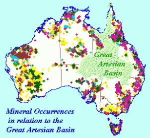
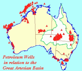
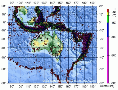
In the summer of 1901-2, Professor J. W. Gregory, Head of Geology at the University of Melbourne, took a party of students to Central Australia, and inspected the flowing wells near Lake Eyre. Gregory noted the chemical composition of the waters, the bore water temperatures and heat flow, the relationship of the Basin with the volcanism in eastern Australia and noted the existence of metal mines adjacent to the Basin at Broken Hill, Cobar and Mt. Isa. He concluded that the artesian waters originated in the crust of the Earth below the Great Artesian Basin. Gregory criticised the prevailing belief in the recharge of the aquifers by lateral seepage over distances of hundreds of miles. He demonstrated that the large head losses involved prohibited the possibility of any recharge from surface rainfall.

Gregory's book "The Dead Heart of Australia" was published in London in 1906. In that book he provided detailed reasons why the Basin was not being recharged from surface rainfall. He prepared a sketch map showing the underground temperature gradients throughout the Basin, and identified the hot spots. He studied the chemical composition of well waters in the Basin, and prepared a sketch map showing the areas where there was a concentration of solid constituents. (Ref. 1).

In 1907 there was a stern refutation of Gregory by E. F. Pittman, Government Geologist of New South Wales, in a paper to the Royal Society of New South Wales entitled "Problems of the Artesian Water Supply of Australia, with special Reference to Professor Gregory's Theory". (Ref. 2)

When we read that 1907 paper by Pittman it is evident that the firm views of Gregory were a great embarrassment. But the level of understanding of the matter by Gregory was not shared by anyone in Australia, or overseas. That did not seem to worry Gregory. The fascination of science and exploration and discovery were his life.

But it was a worry to Pittman, the Government Geologist of New South Wales. At one point in his paper, Pittman pleads,

"Suffice it to say that the view adopted by most American geologists, viz. That 'all underground waters have their origin in rainfall' has much to recommend it."'

Pittman concluded,

"It may be confidently re-affirmed that the great Australian water-bearing basin is a true artesian area, that the water of the flowing wells had a meteoric and not a plutonic origin."

Reading that paper almost a century later, one has the impression that Pittman was not really confident and simply hoped that the matter was settled.

Gregory waited five years before replying. He was then Professor of Geology at the University of Glasgow. In 1911 he published a very comprehensive paper in the Geographical Journal of the Royal Geographical Society. It is a very detailed analysis of the scientific data on the Great Artesian Basin at that time. (Ref. 3)

In 1914, Pittman responded with a similarly comprehensive rebuttal of the 1911 paper by Gregory. (Ref.4)

Pittman, in the conclusion of his 1914 paper, noted that he "regrets the extremely controversial character of this paper", but it was necessary because the Gregory paper of 1911 "contains a number of emphatic statements which ...are based upon insufficient or unreliable data."

The 1914 paper by Pittman was the end of the debate. For the rest of the century, minds were shut.

The great Rift Valley in Africa

Prior to being appointed as Professor of Geology at the University of Melbourne, Gregory was a member of the staff of the British Museum. His travels for the Museum included field trips to America to see the Rocky Mountains and the geyser fields in Wyoming, a crossing of Spitzbergen, and also to the West Indies.

In 1895 he was sent to visit the Rift Valley in British East Africa, organising a caravan of porters on his arrival. He explored the Rift Valley, the nearby volcanoes, the lava fields and the geothermal springs, and also the glaciers of Mount Kenya.

Gregory was only in East Africa for 5 months, and travelled mostly on foot, but his book on the expedition is still in print over 100 years later. His book describes a daring expedition of discovery into dark Africa. It reflects the audacity of the British explorers of the Victorian era who confidently strode out into the unknown. Gregory was the first person to use the term the "Great' Rift Valley. The section of the Valley in Kenya became known as the Gregory Rift.

His understanding and explanation of the creation of the Rift Valley is still recognised as a major advance. In his book he described how the Rift Valley was a zone of lateral extension in the crust of the earth, which was a most perceptive observation at the time. The crustal extension created vertical fracture zones and fissures on which the nearby volcanoes were based. This zone of vertical fractures also permitted the ascent of plutonic waters that gushed to the surface as geysers and hot springs.


FIGURE 1. Along the floor of the Rift Valley there is a series of lakes, most with many hot springs which pour boiling alkaline waters into the lakes. These hot lakes attract birds by the millions, especially flamingos. When Gregory set eyes on Lake Bogoria in 1892 he described the scene as the most beautiful in Africa.


Water in the Universe, and in the interior of the Earth

The critical point of departure of Gregory with his contemporary colleagues was his clear understanding that there is water deep within the crust of the Earth. He referred to these deep waters as 'plutonic' waters, as distinct from water from surface rainfall, which he referred to as 'meteoric' waters. This is a distinction that is still not recognised by the profession of groundwater hydrologists, worldwide, who seem to regard all underground water as derived from surface rainfall.


FIGURE 2. Newborn stars are forming in the Eagle Nebula. This image, taken with the Hubble Space Telescope in 1995, shows evaporating gaseous globules (EGGs) emerging from a pillar of molecular hydrogen gas and dust. These giant pillars in the Eagle Nebula are light years in length and are so dense that the interior gas contracts gravitationally to form stars. At each pillars' end, the intense radiation of bright young stars causes low density material to boil away, leaving stellar nurseries of dense EGGs exposed. The Eagle Nebula, associated with the open star cluster M16, lies about 7000 light years away.
Credit: J. Hester, P. Scowen (ASU), HST, NASA


FIGURE 3. The Crab Nebula, filled with mysterious filaments, is the result of a star that was seen to explode in 1054 AD. This spectacular supernova explosion was recorded by Chinese astronomers. In the above picture taken recently from a Very Large Telescope, the color indicates what is happening to the electrons in different parts of the Crab Nebula. Red indicates the electrons are recombining with protons to form neutral hydrogen, while blue indicates the electrons are whirling around the magnetic field of the inner nebula. In the nebula's very center lies a pulsar: a neutron star rotating, in this case, 30 times a second.
Credit: FORS Team, 8.2-meter VLT, ESO


FIGURE 4. DEEP OCEAN VENTS
Further evidence of deep crustal sources of water is the deep ocean vents. These are hydrothermal vents in the ocean floor that release hot, acidic waters from deeper within the earth. The concentrated hot solutions precipitate metal sulphides on contact with the cold sea water, including zinc, iron and copper sulphides.

These deep plutonic waters play an important role in the evolution of the rocks and geological structures of the Earth.

Gregory was well aware of this critical role of water in deep crustal processes. He knew that magmatic rocks such as granite contain water. He stated that rocks such as granite require water for their formation. He referred to the fact that the milky whiteness of quartz is due to the presence of microscopic globules of water.

Arrhenius, the Nobel Prize winning Swedish scientist, suggested in 1903 that rocks deep within the crust, at high pressures and temperatures, probably absorb water in silicate solutions or as a hydrous melt. He surmised that if the rock contains less water than it can absorb at the given conditions of temperature and pressure, then the rock melt will absorb more water until it is saturated. (Ref. 5).

Arrhenius pointed out that at high temperatures the dissociation of water into positive and negative ions created a strong solvent capable of dissolving silica and silicates. Thus hydrothermal solutions could become increasingly concentrated, forming a silicate melt with a high water content. Metal mineral occurrences were regarded as precipitates from these high temperature concentrated solutions.

At the turn of the century in 1900 scientists were also aware of the then recent astronomical studies using spectroscopes to analyse the components of the light from the stars. Those analyses revealed the seeming abundance of hydrogen. That led to thoughts of the probable abundance of hydrogen compounds such as water, methane, ammonia and hydrogen sulphide. Thus the earth could contain these compounds.

Today, a century later, we have the benefit of satellite observatories, (Ref. 6), and space probes within the solar system which are steadily revealing that hydrogen is abundant in the universe, and that water and methane also abound.

Satellite and ground-based images are now providing a flood of data about the universe, and providing a better understanding of the evolution of our solar system and the Earth. We are finding out that water is abundant in space. It was recently reported that water is forming in the Orion Nebula at a rate that could fill the Earth's oceans 60 times each day.

At the moment a spacecraft is heading towards Saturn where it will fly by the moon Titan, and parachute a probe into the atmosphere of Titan. Hopefully it will land on a surface, if there is a solid surface. Titan is of intense interest because of the dense atmosphere that extends fully 200km above the apparent surface.

Titan's atmosphere seems to be a thick smog of mostly hydrogen compounds - water, ammonia, methane and, apparently, complex hydrocarbons.

If there are complex 'organic' molecules on Titan, it raises interesting questions about the origin of petroleum and natural gas in the Earth. It is noted that the waters released from the deep bores of the Great Artesian Basin include methane. The origin of the methane in the Basin may not be from biological sources but may have been present since the creation of the Earth.

The integrated view


FIGURE 5. Map of Australia taken from Encarta World Atlas and which has been marked to show the features that were noted by Gregory in 1901-2. One feature is the many and extensive lava flows, and extinct volcanoes, covering an area from Torres Strait to Tasmania. Another feature is the concentration of metal mines adjacent to the outline of the Great Artesian Basin. The author has also included the line of offshore sea mounts which are a later discovery but relate to the broad picture described by Gregory. The blue line is the line of the section in Fig 6 below.


FIGURE 6. Vertical Section drawn along a line from west of the northern edge of Lake Eyre to Lord Howe Island. Although the vertical scale is exaggerated, note that the ground surface from Lake Eyre to the edge of the Great Divide is remarkably flat. The dramatic difference is offshore, where there is a huge rift valley 4500 metres deep, in which there is a line of old volcanoes 4000 metres high.

Another major difference between Gregory and his critics was his broad integrated view of the structural geology of eastern Australia. The accompanying map of Australia shows the relationship of the Great Artesian Basin to the zone of volcanism extending from Torres Strait to Tasmania, and the nearby metal mines at Broken Hill, Cobar, Mt. Isa and Mt. Morgan. Gregory drew attention to this broad picture. He was the only one at the time who noted the significance of each part of the whole.

Over the past few years we have gained much more information on the topography of the ocean floors. Australia now has its own great rift valley, immediately off the east coast. This rift valley has steep sides, a wide floor at a depth of 4500 metres which is called the Tasman Abysmal Plain. On this plain there are a series of old volcanoes, some over 4000 metres high.

The great magnitude of this undersea rift valley is quite extraordinary in world terms. The Tasman Abysmal Plain is probably bounded by a sequence of major north-south faults that run parallel to the coast. The differences in level suggest major differential movements. There must have been a multitude of such movements. It is also remarkable that this great tectonic structure has been relatively quiet in seismic terms since the settlement of Australia. The western scarp of the rift passes near Newcastle, where there was an earthquake in 1989.

Most of the sediments of the Great Artesian Basin are marine sediments. Thus, the uppermost strata in the sequence must have been below sea level at the end of deposition. This indicates that the entire thickness of the sequence of saturated and partially consolidated sediments would have been below sea level when the uppermost sediments were being deposited. It follows that the base of the sedimentary series must have been at a level of 4000 metres or more below sea level, say the same level as the present level of the ocean floor of the Tasman Plain.

But the entire sequence is now elevated and consolidated. That indicates that there have been substantial changes in the elevation of much of Australia since the beginning of deposition of sediments in the Great Artesian Basin.

The strata of the Great Artesian are relatively undisturbed by faulting, and are essentially flat for hundreds of kilometres, north and south, and east and west. It follows that all that vast area of Australia, which was underwater when the Basin sediments were being deposited, has since moved up and down as one huge block, and over a vertical range of at least 4000 metres. There was probably a succession of movements, dating from the Triassic or earlier, and successive periods of sedimentation, uplift, erosion and subsidence.

Tectonic geologists are now seeking to explain the reasons for this remarkable series of events. (Gurni, Ref 12,13.) Their present approach is to relate the movements to the concepts of plate tectonics, whereas I believe that the greater understanding of the expanding universe and the speculation about dark energy is leading us back to the concept by S. Warren Carey of an expanding Earth. (Ref. 14)

Thus the sediments of the Great Artesian Basin have remained essentially intact throughout the time of these great tectonic periods of uplift and subsidence. The seismic events would have released deep water and gases to escape towards the atmosphere. But the intact sediments were an effective impermeable barrier to the upward migration of geothermal fluids and gases to the surface of the Earth, including the upward movement of water and methane. The water and the gases would have accumulated under the impermeable barrier of sediments. That is a much more probable reason for the existence of the resources of water and natural gas in the Great Artesian Basin.

The strata of the Great Artesian Basin

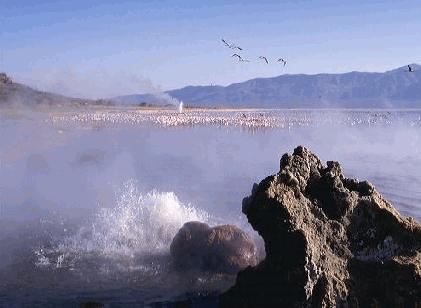
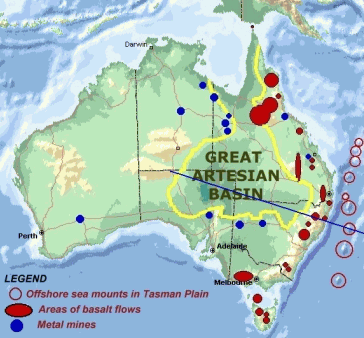
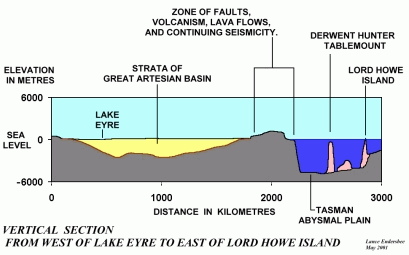
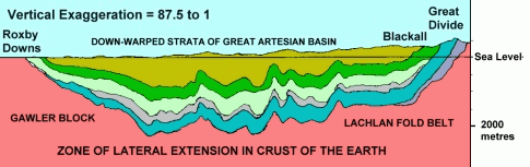
Figure 7. Profile of the Great Artesian Basin from Roxby Downs to Blackall. These sediments were deposited below sea level, nominally in horizontal layers. There is indication of some sagging of the base during continued deposition. This whole area of Australia must have been uplifted above sea level, the sediments became consolidated, there was further sagging, and some lowering of this whole area of Australia relative to sea level.

The consolidated sediments which form the Great Artesian Basin act as a vast impervious blanket covering about one fifth of Australia. Because of the differences in thermal conductivity of the sediments and the crystalline bedrock, the sediments also act as a significant thermal blanket.

The blanket of sediments is relatively thin in relation to the great lateral dimensions of the Great Artesian Basin, which measures about 1000km from east to west and 1500km from north to south. The sediments have a maximum thickness of 2000 metres. The ratio of thickness to lateral extent is only about 1 in 500 in the coverage from east to west of 1000km.

Even so, this thin and intact blanket of sediments has had an important influence on the evolution of the metallic mineral resources in the region, and the natural gas and petroleum resources in that part of Australia.

The present maximum thickness of dry consolidated sediments is about 2000 metres. When the uppermost sediments were still being deposited under water, and before uplift and erosion, the total thickness of partially consolidated sediments may have been 2 or more times the present maximum thickness - say 4km depth or more of sediments.

The offshore rift valley, the volcanism, and the saucer shape of the Basin all indicate that the region is a zone of lateral extension in the crust of the earth. This lateral extension of the crust means that there was a system of vertical fractures in the crystalline rocks below the sediments. This would have permitted the accumulation of plutonic waters. and natural gas under the impervious sediments.

Occurences of metal minerals

The combination of great crustal movements together with the maintenance of the lateral continuity of the sediments helped to concentrate the upward migration of hydrothermal fluids to the perimeter of the Great Artesian Basin. A century ago, Gregory noted the concentration of mines nearby. There are many more today.


FIGURE 8. Occurrences in Australia of metal ores of copper, lead, zinc, nickel, silver, gold, uranium, and iron. Note the concentration of resources around the periphery of the Great Artesian Basin. The mineral data is from the website of the Australian Geological Survey Organisation, (AGSO).

We now have much more information on location of metal minerals. The accompanying map shows the location of occurrences of resources of metal minerals in Australia. An outline of the Great Artesian Basin has been added. That outline did not cover any known resources of metal minerals, although there may be some deposits in the bedrock below the strata.

The concentration of mineral resources in areas immediately adjacent to the outline of the Basin is quite remarkable, and indicates a cause and effect relationship extending over several periods of geological history.

Water, methane and methane hydrate

From the beginning of drilling for bore water over a century ago, it was noticed that the flow of water was accompanied by the emission of natural gas. The gas was sometimes collected and used for lighting. Many bores today are still releasing natural gas to the atmosphere.

The actual close relationship of water and natural gas in underground reservoirs was difficult to comprehend in the early days. Methane is sparingly soluble in water at normal temperatures and pressures. But the situation is dramatically different at the very high pressures encountered in reservoirs in rocks deep underground.

At constant temperature, the solubility of a gas in a liquid is proportional to pressure, (Henry's Law).

At a depth of 1000 m. in rock, the overburden pressure of the rock is, say, 260 atmospheres. At that depth, water under rock pressure would show an increase in solubility of gas in water equal to 260 times that at atmospheric pressure and the same temperature.

This great difference in solubility means that underground waters at great depth have an enormous capacity to absorb gases, including natural gas.

It also means that any reduction in the pressure in underground waters leads to the release of large quantities of dissolved gases.

It is understandable that when the very first bores were drilled into the Great Artesian Basin there was an inevitable release of great quantities of natural gas. There was no concern at the time about the waste of natural gas. Today, 120 years later, natural gas is still being vented to atmosphere from uncontrolled bores, and there is still no concern.

When there is a high concentration of methane in water at high pressures and moderate temperatures, the structure of the solution may change to methane hydrate, a substance rather similar in appearance to ice. Methane hydrate has a cage-like lattice of water molecules that enclose the molecules of methane.

Solid methane hydrate contains 160 times its own volume of methane gas when measured at standard temperature and atmospheric pressure. In effect it is a highly concentrated form of natural gas, having the appearance of solid ice.

Since the 1970's, many large deposits of natural gas hydrate have been discovered worldwide. Large deposits of methane hydrate have been discovered in offshore drilling around most continental margins, and in on-shore drilling. Methane hydrate is also being recognised in places where it was previously thought that the methane was in the gaseous form or in solution in water. (Ref. 15)

It is of interest to note that the indicated resources of natural gas stored as gas hydrate are now estimated to be over twice the amount of the present known gas reserves. However, the recovery of these deep ocean gas hydrates may be quite costly.


Figure 9. Petroleum Wells in Australia, in relation to the Great Artesian Basin.

Returning now to the question of the Great Artesian Basin. The sediments of the Basin were also ocean sediments, and it is probable that they also once contained gas hydrates. With the subsequent uplift of 4000 m., and the consolidation of the strata, it is probable that most of the gas escaped to atmosphere. What gas now remains is in small pockets of gas in solution, trapped underneath the impervious lower boundary of the strata of the Basin.

Within the Great Artesian Basin, the drilling of bores for water, and drilling for petroleum, has continued over many decades as if there was no relationship between the two. There was no thought that natural gas may be in solution in the water. The entire area of the Basin now has over 7000 water bores, and about 10,000 dry bores. It raises the serious question as to whether there are any water bores that may be compromising the long term yield of the petroleum and gas production wells.

The ballistics of volcanoes

This discussion of the ballistics of volcanoes is included to show that the magma below the crust of the earth includes a large proportion of dissolved gases in the melt. A major component of the dissolved gases in the rock melt is water. There is also methane in the water.


Figure 10. The major product of volcanoes is steam, and it is the expansion of steam from superheated water that provides the enormous propelling forces that may blow the tops off volcanoes and hurl disintegrated rock and dust tens of kilometres into the air. The source of the water may be tens of kilometres down, with the core of the volcano being probably straight and vertical over that distance.

The characteristic central core of volcanoes is near circular in horizontal section, and vertical, and can be regarded as a gun barrel that has been reamed by the explosive emission of disintegrated rock driven by gases, mostly steam.

Other volcanic gases besides steam include hydrogen, methane, nitrogen, hydrogen sulphide, carbon dioxide. These volatiles are dissolved in the magma, as dissociated ions. Because of the very high pressures in rocks at great depth, the proportion of volatiles dissolved in the magma may be quite high. The maximum level achieved in laboratory studies of silicate melts is about 11 percent. At great depth it may be substantially more than that.

Such rocks at high temperatures and pressures, and with dissolved gases, are potentially unstable if exposed to lower pressures. This may occur in a crustal zone of lateral extension, where vertical fissures may form through the crust down to the magma. An erupting volcano, with great clouds of steam and dust being thrown tens of kilometres into the air, can be regarded as the spontaneous disintegration of magma at great depth. The disintegrated fragments of rock and the gases create an effect like a sandblaster, blasting a straight vertical hole through the overlying rocks over distances of tens of kilometres.

The Great Artesian Basin adjoins a wide zone of volcanism. It is reasonable to expect that gases from the magma such as water, methane and hydrogen sulphide may have accumulated over time under the vast impervious blanket of sediments of the Great Artesian Basin.

Recent seismicity in the area

The eastern side of Australia from Torres Strait to Tasmania is one of the most extensive volcanic zones in the world. It is now quiet.


Figure 11. Seismicity in the Australian region over the 20 year period from 1977 to 1997. Note that there are occasional small earthquakes in eastern Australia and at the shallow depths less than 33km.

Even though there has been no volcanism in eastern Australia over the past few hundred years, this may be only a dormant period between events. The most recent active volcano erupted 4600 years ago, at Mount Gambier. That is very recent in geological time.

This area of geologically recent volcanism continues to show minor seismicity at relatively shallow depths. This may indicate that upward migration of water may still be occurring.

The largest volcano in Australia may have been Mt. Warning, on the coastal scarp just near Tweed Heads and the Gold Coast. It is dated at 20 million years. It is now eroded, but it has been estimated that the height was some 2000m. higher than present ground level.

There are occasional small earthquakes in the eastern part of Australia, at relatively shallow depths of less than33 km. In 1989 there was a small earthquake at Newcastle. Newcastle is on the same north-south lineament as Mt. Warning.

Earth tides and oscillating wells

As stated earlier it has been assumed for more than a century that the waters of the Great Artesian Basin are being recharged by lateral flow from surface rainfall on the exposed eastern margin of the strata. This has led to the plotting of 'inferred flow lines'.


Figure 12. This diagram is taken from the website about the Great Artesian Basin prepared by the Queensland Government. It describes the mode of operation and the management of the Basin by the Queensland Department of Natural Resources. The lines of arrows on the map show the inferred direction of flow from the intake beds. As far as the author can ascertain, there is no evidence at all to justify those flow lines. The whole diagram is quite imaginary. The diagram shows the intake beds that the Queensland Government claims to be the areas where rainfall provides the water source for the artesian wells throughout the Basin. The Queensland Government has recently proclaimed the intake areas in their state, but the reasons for that action may be political rather than scientific.

The inferred flow lines are in the general direction of east to west, or north-east to south-west. Velocities of movement of groundwater have been studied by detection of isotope movement between close boreholes. The indicated rate of flow is only 0.8 to 2.5 metres per year. Those low figures do not suggest any lateral recharge whatsoever.

The author considers that the small indicated movements of groundwater from east to west may be the result of the progressive effect of earth tides. It is noted that there are tides on the land surface of the earth similar to and smaller than the tides in the oceans. Because of the short duration and small magnitude of these diurnal changes in gravitational forces, the corresponding response of the solid earth is elastic.

There is a corresponding influence on groundwaters. In continental areas, the groundwater pressures may change with the tides, but opposite in phase. This has been known for two millenia, (Ref. 9 p.2) "the wells are lowest when the tide is high and begin to refill when the tide ebbs".

Thus the effect of a high tide on the elastic crust of the earth is to increase fracture openings at depth, which is reflected in a drop in water pressure in a well.

These tides in the groundwater can be regarded as long waves which travel from east to west twice each lunar day. There is progressive increase and decrease in the fracture openings in the rock as each long wave passes by.

This would have the effect of causing a slow migration of the groundwater in the general direction from east to west. It would also lead to a 'smoothing out' of differences in groundwater pressure.

As well as tidal oscillations in pressure in wells, there may also be oscillations due to geothermal effects. An example is the Old Faithful Geyser in Yellowstone Park. Sudden changes in atmospheric pressure may also be reflected in small changes in water level in a well.

Gregory, in his book of 1906 referred to the Urisino Well in the north-west corner of New South Wales. This well, measured by tidal gauges in 1897, showed oscillations from low to high of over 4 feet, and with remarkably regular cycles. But the cycles were not coincidental with the lunar tides. The oscillations were similar to lunar tides but with a slightly shorter period.

It is evident that Gregory reviewed the data on this well, and could offer no explanation for the oscillations. The author has also reviewed the data on the Urisino Well, is similarly puzzled, and even disappointed that the data did not fit with the concept of earth tides.

But these measurements in 1897 are the only record of oscillations in pressure in a well in the Basin. Although there are several references to oscillating wells, there do not seem to be any other measurements in this past century.

Hydrochemistry of the bore water

For over a century, the bore waters of the Basin have been subject to chemical analyses, with apparently similar results in the same areas and depths over time.

There is a recent comprehensive report by the Bureau of Rural Sciences, a science agency within the Federal Government. The title of that report is of interest:

Hydrochemistry and implied hydrodynamics of the Cadna-owie-Hooray Aquifer, Great Artesian Basin. (Ref 16)

Apparently the major object of the report was to study the available hydrochemistry data and to use it to justify the implied hydrodynamics of lateral flow over hundreds of kilometres from surface rainfall on the implied recharge areas.

It is quite evident in the report that the hydrochemical data certainly does not support the implied hydrodynamics. That raises the question as to why the Australian Government prepared the report?

The regional variations in the concentrations of the various ions suggest that the source of the chemicals is local and deep. The report shows that the concentrations of ions both increase and decrease quite markedly along the implied direction of flow, which does not support the concept of lateral flow, but separate local sources at depth.

When Gregory saw similar hydrochemistry data a century ago, he stated firmly that the source of the waters was deep in the crust of the earth. The source was not in surface rainfall at a great distance. I maintain he was right. All of the recent data assembled in the report a century later simply confirms his assessment.

One may ask whether the range of hydrochemistry analyses included in the report was deliberately chosen to confirm the implied hydrodynamics of the origin of the waters in surface rainfall? If the question of possible plutonic origin had been considered, there would have been a different range of hydrochemical analyses. For example, it would have been helpful to include an assessment of the gases that are known to be present in these waters such as hydrogen, helium, hydrogen sulphide, nitrogen, ammonia, methane and the other components of natural gases.

Although this report by the Bureau of Rural Sciences is a very substantial document with a mass of data and excellent charts, one is left with the uneasy feeling that the authors of the report were not convinced by their findings, and were simply writing a report.

The broad view

For over 100 years the management of the resources of the Great Artesian Basin has been caught in a web of divided interests. These involved state governments, state versus state, states versus the federal government, and competing interests of water authorities, oil and gas companies, shire councils, farmers and mining companies.

The Great Artesian Basin is a clear example of the way the division of responsibilities may stifle the effective management of resources, and frustrate scientific inquiry, thereby leading to scientific and professional weakness.

There is now a need to review and revise the entire approach to management of these declining resources of groundwater. This could involve measures to detect any concentrations of the deep sources of groundwater, and to assess prospective and sustainable flows.

It is hoped that this paper will demonstrate that a broad and thoroughly professional approach is desirable if we are to make progress in science or human affairs. Narrow specialisations can lead people down rabbit warrens, where they may burrow away happily for decades, avoiding and ignoring contrary evidence, and losing sight of the sun and the sky and the exciting progress of knowledge in the world.

Author's Note:
This paper is the fourth of a recent series of papers by the author on the Great Artesian Basin. The other papers will shortly be available on the website of the Academy of Technological Sciences and Engineering:

  • L. A. Endersbee, " The Great Artesian Basin of Australia"

  • L. A. Endersbee, " Reservoirs in Naturally Fractured Rock"

  • L. A. Endersbee, "The Plutonic Waters of the Great Artesian Basin" 

REFERENCES:

  1. J. W. Gregory, "The Dead Heart of Australia", John Murray, London, 1906.

  2. E. F.L Pittman, "Problems of the Artesian Water Supply of Australia, with Special Reference to Professor Gregory's Theory"; Journal R. Soc. NSW.., Vo.44, 1907 pp.100-1339

  3. J. W. Gregory, "The Flowing Wells of Central Australia", Geogr. Journal, 1911, XXXVIII, No. 1 (July), pp 26-59, and No. 2 (August), pp. 157-181.

  4. E. F. Pittman, "The Great Australian Artesian Basin and the Source of its Water, Department of Mines, Geological Survey of NSW, Government Printer, Sydney, 1914.

  5. A. Holmes, "Principles of Physical Geology", Thomas Nelson, 1965, p 1024.

  6. NASA, "Astonomy Picture of the Day": "The Colorful Orion Nebula", Sept. 14, 1999. On Web as: http://antwrp.gsfc.nasa.gov/apod/archivepix.html

  7. NASA "Astronomy Picture of the Day": "M51: The Whirlpool Galaxy in Dust and Stars", April 10, 2001. On Web as: http://antwrp.gsfc.nasa.gov/apod/archivepix.html 

  8. SPACE DAILY, an internet journal. http://www.spacedaily.com/news/cassini-o1c.html

  9. P. Melchior, "The EarthTides", Pergamon, 1966.

  10. J. Favela and D. L. Anderson, "Extensional Tectonics and Global Volcanism" http://www.gps.caltech.edu/~dla/erice_paper.html

  11. V. Beyerle, et al, "Some Noble Gas Recharge Temperatures from the Great Artesian Basin ..." http://www.internal.eawag.ch/~beyerle/Publications/Abstracts/Peking.html

  12. M.. Gurnis, "Sculping the Earth from Inside Out", Scientific American, March, 2001.

  13. M. Gurnie, et al, "Cretacious Vertical Motion of Australia and the AustralianAntarctic Discordance", Science, Vol279, March 1998, pp 1499-1504.

  14. S.W. Carey, "The Expanding Earth", Elsevier, Amsterdam, 1976.

  15. "Gas Hydrate: Where is it found?", United States Geological Service, Woods Hole Field Centre. http://woodshole.er.usgs.gov/project-pages/hydrates/where.html

  16. B.M. Radke, et al, Hydrochemistry and implied hydrodynamics of the Cadna- owie-Hooray Aquifer, Great Artesian Basin." Bureau of Rural Sciences, Commonwealth Department of Agriculture, Fisheries and Forestry, Australia. 2000.